
মধুপুরের মানচিত্র (Map of Madhupur)
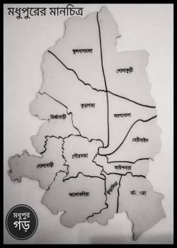
This is a map of Madhupur Upazila (মধুপুর), a sub-district in Tangail District, located in the Dhaka Division of Bangladesh. The map is titled:
Contact
Location: Madhupur Map
Nearby Location: Dhonbari Upozila
Opening Time: 24 hours
Closing Time: N/A
Posted by: Admin
Published on: Apr 23, 2025
This hand-drawn style map shows the administrative and local union divisions of Madhupur Upazila. The black boundary lines divide the upazila into several unions or areas. Some key places labeled in Bengali on the map include: ফুলবাড়িয়া (Phulbari) শোলাকুড়ি (Sholakuri) আনন্দবাজার (Anandabazar) আউলিয়াবাড়ি (Auliabari) মির্জাবাড়ী (Mirzabari) গড় কাহারিয়া (Gar Kaharia) পৌরসভা (Pouroshova / Municipality) আলোকদিয়া (Alokdia) বেরীবাইদ (Beribaid) শোলাকুড়ি (Sholakuri) কুড়াগাছা (Kuragachha) অরণখোলা (Arankhola) 📍 Location Context: Madhupur Upazila is known for the Madhupur National Park, a part of the Madhupur Tract – an elevated forested region that’s ecologically important and rich in biodiversity. It's culturally diverse, home to Bengali and Garo communities. The main town area is the Pourashava (municipality) in the center of the map. Surrounding unions and villages play roles in agriculture, forestry, and local trade.